
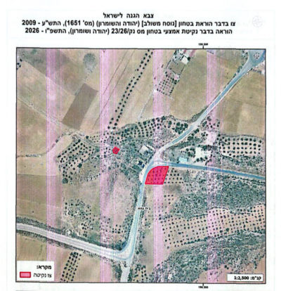
Since the start of 2026, Israeli occupation authorities have issued 49 military orders under the label “security measures,” targeting about 2,093 dunams of Palestinian-owned land across the occupied West Bank.
The Wall & Colonization Resistance Commission has reported that these orders do not formally transfer ownership but impose far‑reaching material and legal restrictions: removal and pruning of trees, bans on replanting, and long‑term measures that severely limit access and use. The result is de facto seizure and functional control without official confiscation.
Issued under the pretext of security and military needs near colonies, colonial roads, the annexation and expansion wall, military roadblocks, and bases, the geographic spread of these orders shows a broader purpose: re‑engineering the space around the colonial infrastructure, expanding effective control, and shifting the burden of securing colonizers’ movement onto Palestinian land and its owners.
In the first half of 2026 alone, the number and area of targeted lands already exceed the full‑year totals of 2025 (47 orders, 1,613 dunams), reflecting a clear acceleration and the transformation of these orders into a regular tool to remove Palestinian tree cover and widen protection belts around colonies and roads.
Most orders are concentrated along key colonial roads (35, 354, 449, 60, 356) and around major colonies such as Ariel, Modi’in Illit, Mevo Horon, and Eli. Tree removal is thus embedded in the settlement project, serving to secure the colonial movement network, expand control margins, and reshape surrounding areas to fit the needs of colonizers and the military apparatus.
The impact extends beyond the plots listed in the orders: controlling strips of land along roads and colonies restricts access to larger areas behind them, creates new informal security zones, and imposes continuous limits on movement, farming, and grazing.
Among the largest orders are 63/26 (164.624 dunams from Marda, Iskaka, and Salfit around Ariel), 17/26 (139.152 dunams in Ramin), 45/25 (121.6 dunams in Safa and Beit Sira, published only in 2026), 49/26 (about 117 dunams in Safa), 52/26 (106.507 dunams in Azzun and Kafr Thulth), and 18/26 (95.692 dunams in Beita and Huwwara.
The succession of orders in contiguous areas—Ni’lin, Deir Qaddis, Safa, Beit Sira, Beit ‘Ur west of Ramallah, and multiple locations in Hebron (Beit Kahil, Idhna, Dura, Sa’ir)—shows a cumulative strategy targeting interconnected geographic sectors around colonial roads and colonies, producing wide belts of restricted land even when each order is issued separately under a specific security pretext.
The data also reveal overlap with other tools of land control: parts of the targeted areas had already been declared “state land.”
This layered use of declarations, military orders, access restrictions, and tree removal converts claimed legal authority into sustained field control and prevents Palestinian owners from using or reclaiming their land.
Targeting the tree layer—especially old, long‑lived trees—hits a central pillar of Palestinian presence, undermining economic resources and the documented continuity of cultivation and care. As trees are removed and access is blocked, lands risk becoming classified as “unused,” opening the door to further measures.
These orders expose structural discrimination in land and resource management: while Palestinian trees and crops are uprooted and access is restricted, the occupation simultaneously develops roads, infrastructure, and security zones serving colonizers, granting colonies additional space for protection, expansion, and movement.
Palestinian villages thus bear the cost of securing the colonial project through shrinking their agricultural domain and restricting their mobility, while the security pretext becomes a mechanism for redistributing space in favor of colonizers.
The high number and broad spread of these orders underscore their role as a flexible, rapid instrument for imposing direct changes on the ground without formal confiscation. Land may remain registered to its Palestinian owners but is effectively removed from use, creating a form of de facto seizure that can later serve as a basis for expanding roads, building security installations, or practically annexing land to colony zones.
The Commission concludes that “security measures” orders are part of an integrated colonial system—combining military orders, settlement planning, “state land” declarations, land‑seizure orders, and colonizer violence—aimed at clearing the space around colonies and roads of Palestinian presence, expanding protection and control for colonizers, and turning new areas of Palestinian land into restricted‑use zones in preparation for their de facto incorporation into the regime of colonialization and annexation.
All of Israel’s colonies in the occupied West Bank, including those in and around occupied East Jerusalem, are illegal under International Law, the Fourth Geneva Convention in addition to various United Nations and Security Council resolutions. They also constitute war crimes under International Law.
Article 33 of the Fourth Geneva Convention prohibits collective punishment and acts of terror against civilian populations.
Article 49 of the Fourth Geneva Convention states: “The Occupying Power shall not deport or transfer parts of its own civilian population into the territory it occupies.” It also prohibits the “individual or mass forcible transfers, as well as deportations of protected persons from occupied territory”.
Articles 53 and 147, prohibit the destruction of civilian property and classify pillage as a war crime.
