
A new report by the group ‘Forensic Architecture’ has found that widespread pesticide contamination from Israel into Gaza has occurred over decades, severely impacting the food grown in Gaza.
The full report follows below:
Staging the terrain
Over three decades, in tandem with the Madrid and Oslo negotiation processes, the occupied Gaza Strip has been slowly isolated from the rest of Palestine and the outside world, and subjected to repeated Israeli military incursions. These incursions intensified from September 2003 to the fall of 2014, during which Israel launched at least 24 separate military operations targeting Gaza, giving shape to its surrounding borders today.
The borders around Gaza—one of the most densely-populated areas on Earth—continue to be hardened and heightened into a sophisticated system of under- and overground fences, forts, and surveillance technologies. Part of this system has been the production of an enforced and expanding military no-go area—or ‘buffer zone’—on the Palestinian side of the border.
Since 2014, the clearing and bulldozing of agricultural and residential lands by the Israel military along the eastern border of Gaza has been complemented by the unannounced aerial spraying of crop-killing herbicides.
This ongoing practice has not only destroyed entire swaths of formerly arable land along the border fence, but also crops and farmlands hundreds of metres deep into Palestinian territory, resulting in the loss of livelihoods for Gazan farmers.

Working closely with the Gaza-based Al Mezan Center for Human Rights, the Tel Aviv-based Gisha Legal Center for Freedom of Movement, and the Adalah Legal Center for Arab Minority Rights in Haifa, Forensic Architecture examined the environmental and legal implications of the Israeli practice of aerial spraying of herbicides along the Gaza border.
(Read the press release from Gisha Legal Center for Freedom of Movement here.)
To this end, our investigation sought to answer the following questions: how do airborne herbicides travel into Gaza? How far into Gaza does it enter? What is the concentration of the herbicide that drifts into Gaza? And what is the damage to the farmland on the Gazan side of the border?
Weaponising the wind
Our analysis of several first-hand videos, collected in the field, reveals that aerial spraying by commercial crop-dusters flying on the Israeli side of the border mobilises the wind to carry the chemicals into the Gaza Strip, at damaging concentrations.
The videos support the testimonies of farmers that, prior to spraying, the Israeli military uses the smoke from a burning tire to confirm the westerly direction of the wind, thereby carrying the herbicides from Israel into Gaza.
Our investigation shows that each spray leaves behind a unique destructive signature. No two aerial sprays will have the same effect, nor can their damage be reasonably predicted by the army, since the location where the toxic chemicals land, and their respective concentrations, depend heavily on the direction and speed of the wind relative to the flight path of the aircraft.
This practice weaponises herbicide spraying as a belligerent act, designed to ‘enable optimal and continuous security operations’.
Farm warfare
In November 2016, in response to a Freedom of Information (FOI) request filed by the NGO Gisha, the Israeli Ministry of Defense confirmed that aerial herbicides are sprayed along the width of the perimeter of Gaza. Aerial spraying is conducted between the Erez crossing in the north and Kerem Shalom in the south, over an estimated area of 12,000 dunums (12 square kilometres).


Following the advice of a contracted civilian agronomist, Israeli military spraying is conducted during key harvest periods, targeting spring and summer crops. Working with the private Israeli civilian aviation firm Chim-Nir (כימ-ניר), the army’s destruction of vegetation along the eastern perimeter is carried out in a continuous manner, using two aircrafts simultaneously, each equipped with a GPS system to enable precision.
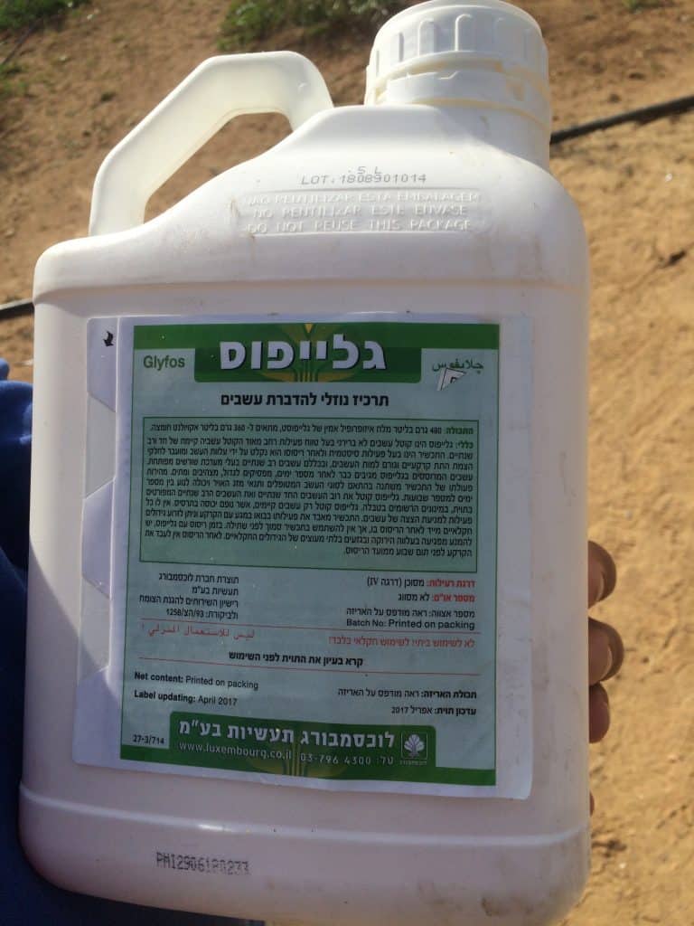
The Ministry of Defense also confirmed that the Israeli military sprays a combination of three herbicides: Glyphosate, Oxyfluorfen (Oxygal) and Diuron (Diurex).
Glyphosate, formulated as ‘Roundup’, is the most widely-used herbicide in the world, leaving traces in soil, foodstuffs, air, and water, as well as human urine. Roundup is the flagship product of the Monsanto Company, a leading agricultural chemicals business that previously produced herbicides and defoliants used by the US military in Vietnam.
In March 2015, the World Health Organization’s Cancer Research Agency classified glyphosate as ‘probably carcinogenic to humans’. Since then, the US Environmental Protection Agency, the European Food Safety Authority and the European Chemicals Agency have ruled it safe for use, although a number of European environmental groups have opposed this ruling.
Oxyfluorfen, formulated as ‘Oxygal’, is manufactured by the Israeli company Tapazol Chemical Works Ltd, and suppresses the growth of certain broad-leaf and grassy weeds. According to the Material Safety Data Sheet provided by Tapazol, Oxygal can cause ‘severe irritation’ upon contact with skin or eyes, and must be ‘kept out of water supplies and sewers’.
The Ministry claimed that it is ‘not carrying out any aerial spraying over the area of the Gaza Strip… [but] only over the territory of the State of Israel along the security barrier’. Citing Israel’s Plant Protection Law, 5716-1956, the Ministry claimed that its spraying practices along the Gaza border are identical to aerial spraying carried out in other Israeli-controlled areas.
However, wind direction is a key factor that determines the movement of aerial herbicides from the purportedly-targeted area, and when effective drift control techniques are not applied, the Israeli army cannot mitigate the reach of those chemicals into Gazan farmland.
Plant scientists have noted that under similar environmental conditions, and with all sprayers adjusted properly, herbicide drift is ‘generally greater from aerial application than from ground application’; the use of ground-based field crop sprayers through tractors reduces the likelihood of extensive drift.
The Israeli military has confirmed that it sprayed aerial herbicides at least thirty times in along the border with Gaza in the period from November 2014 to December 2018. The spring of 2019 season was the first spring season during which the military has not conducted aerial spraying in the past four years.
To date, no Palestinian farmers have ever been compensated for damages to their crops.
Tracking a single spraying
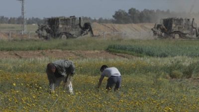
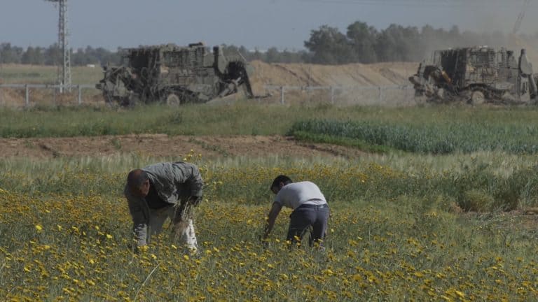
On 5 April 2017, standing on the Gazan side of the border area near Khan Younes, a fieldworker with the NGO Gisha recorded a video of an Israeli crop-dusters spraying herbicides.
Palestinian farmers in the area reported concerns that their crops would be damaged as a result of this spraying, once it was carried by the wind, considering that crops had already been harmed in a previous round of spraying that took place only months prior. Further, most of the crops in the area had been recently sown, making them particularly susceptible to damage from herbicide spraying.


To determine the unique destructive signature of this spraying event, we threaded together evidence derived from vegetation on the ground, the testimony of civilians living and working in the area, and the nature of the environmental elements mobilised in the event.
We identified the plane spraying herbicides along the eastern border of Gaza as a Model S2R-T34 Turbo Thrush.
Using the GPS location of the videographer as recorded on their smartphone, we were able to establish the camera’s cone of vision by comparing the dimensions of visible landmarks, such as a watchtower. Through a process of camera calibration we found the location of the plane and used motion-tracking to model its path, in time and space, as it sprayed.

Our analysis revealed that before each spray, the plane dives to roughly 20m altitude to get closer to the ground. Each spray goes on for a duration of 2–5 seconds, covering the area to be fumigated by travelling back and forth in linear paths.
For the spraying that took place on 5 April 2017, we were able to identify six such spraying paths during the course of the two videos. All six of the sprayings were conducted on the Israeli side, close to the eastern border of Gaza.
Drift analysis
With the assistance of a fluid dynamics expert, Dr Salvador Navarro-Martinez, we sought to determine the extent and concentration of herbicide drift.
To this end, each spray event was simulated using our flight path reconstruction, the local topology, the injector systems fixed to the plane, and meteorological conditions at the time of spraying. We then collected key variables such as wind direction and speed, droplet distribution, and ground chemical deposition to determine the extent of the drift.

The results showed that as the wind moves across the path of the herbicide spray, it carries chemicals westward that are then deposited onto Gazan farmland. The simulation indicates that for the spraying on 5 April, harmful concentrations of herbicide drift reached in excess of 300m into Gaza. This confirms that Palestinian crops could have been harmed as a result of herbicide drift.
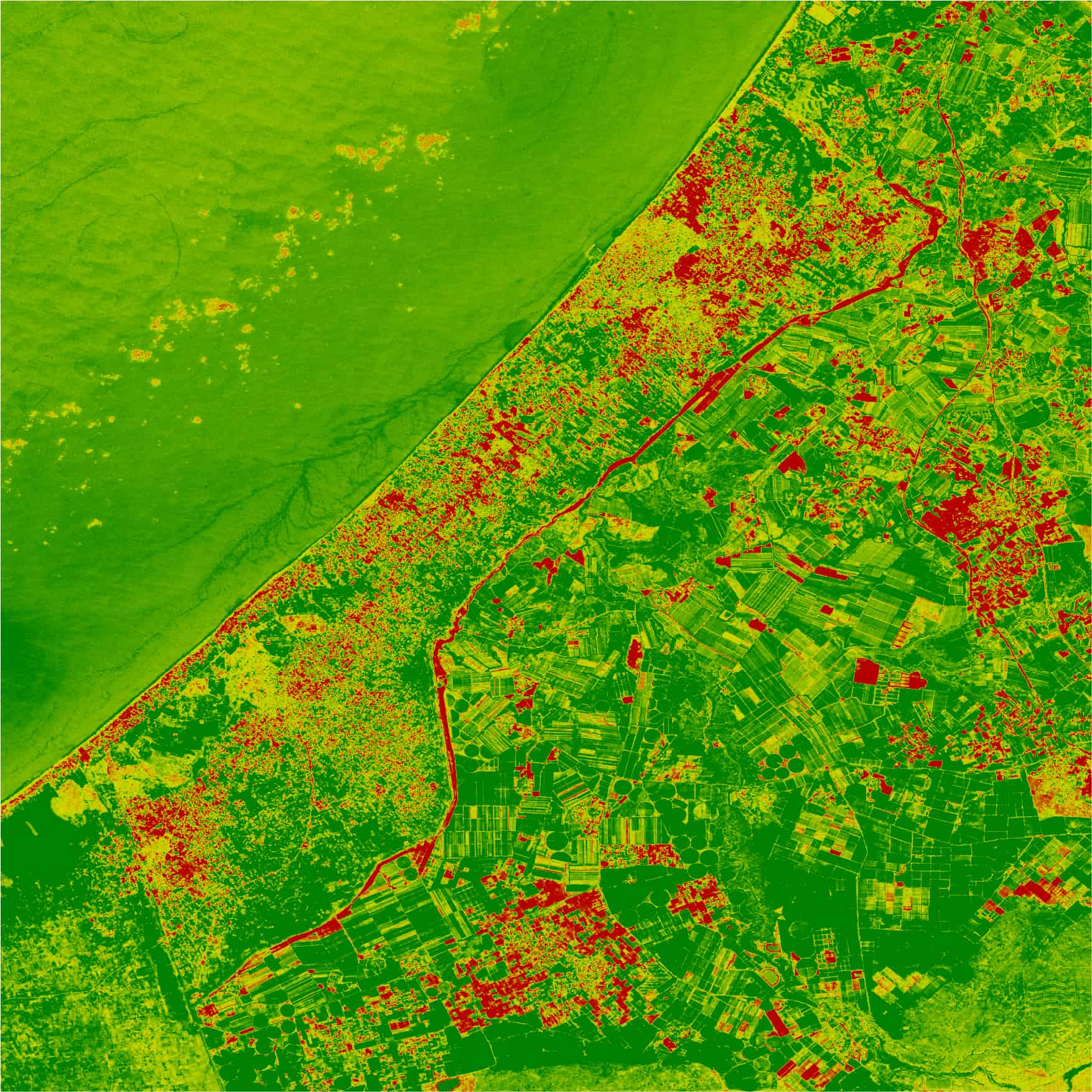
Satellite imagery analysis
Analysis of satellite imagery corroborates the findings of our drift simulation. We compared satellite imagery 5 days after the spraying, and 15 days after the spraying, to reveal visual indicators for the presence and health of vegetation. When the two analyses are overlaid with one another, vegetation degradation becomes visible across much of the same area potentially affected by herbicide drift.
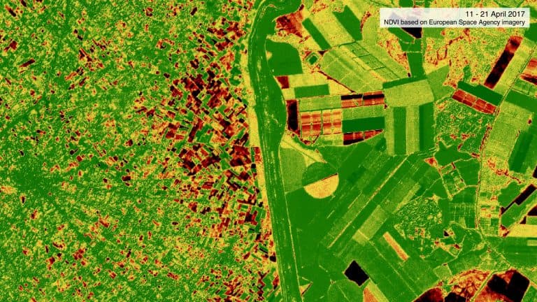
These findings suggest that herbicides carried by winds during and after the Israeli military spraying on 5 April contributed to the degradation of vegetation on the Gazan side of the border, in Khan Younes. We believe that these findings are largely generalisable, since similar vegetation degradation is also visible in other areas in Gaza which are close to the border and in the vicinity of known Israeli target areas for aerial herbicide spraying.
Ground truth
Following another confirmed spraying flight by the Israeli military on 9 and 10 January 2018, also in the Khan Younes area, the Palestinian Ministry of Agriculture actively surveyed dozens of farms that had reported crop damage. Gazan farmers living hundreds of metres away from the border reported damage to crops totaling 250 acres following the January spraying.
Three days after another spraying in December 2018, we gathered similar samples of leaves that exhibited characteristic damage from a contact herbicide.


Leafy crops sampled from two locations along the border with Israel in East Gaza and Juhor ad Dik, hundreds of metres into Gaza, revealed visible damage from fungal pathogens, insect feeding, and possible herbicide drift carried by the wind into Gaza. Corroborating human testimony on the ground, leaves of plants along the Israel-Gaza border function like sensors, recording memories of environmental violence.
Aerial spraying: Less control, unpredictable damage
When analysing the elements of a single spraying event on 5 April 2017, the testimonies of farmers, satellite imagery, and drift analysis we have gathered all confirm that agricultural lands more than 300m from Gaza’s eastern border experienced damage, and with concentrations of herbicides above the recommended amounts for drift, according to the European Union.
Evidence derived from vegetation on the ground, civilian testimony, and the environmental elements mobilized in the spraying event all correspond to show that the Israeli practice of aerial fumigation at times when the wind is blowing into Gaza causes damage to farmland hundreds of metres inside the besieged strip.
This confirms that as a practice for the clearing of vegetation, aerial spraying causes indiscriminate damage: the effects are less readily controllable, and the extent of damage to Palestinian farmland per spray is largely unpredictable. As such, the Israeli military cannot guarantee the reach of the chemicals it sprays by air, nor ensure that those chemicals remain proportionate to the declared objective of improving visibility for security operations.
Israeli military authorities continue to reject calls to end the practice of aerial herbicide spraying along the border with the Gaza Strip. Israel does not coordinate or share the proposed timing of planned operations with the Palestinian Ministry of Agriculture, the International Committee of the Red Cross, or with Gazan farmers, a practice which could mitigate some of the harm to those farmers’ property, and possibly to the surrounding environment as well.
Damage to land, health and livelihoods
The inability to control both the effects and reach of this ongoing military practice along the eastern border enacts a heavy price on Gaza’s farming community and the broader civilian population.
The Palestinian Ministry of Agriculture estimates that between 2014 and 2018, herbicide spraying damaged upwards of 13,000 dunams of farmland in Gaza. The NGO Al-Mezan has further warned that, in addition to crop damage, the long-term consumption by livestock of plants affected by the sprayed chemicals has negative effects that may harm the health of humans who then consume meat from those livestock.
In the context of an ongoing Israeli blockade—with restrictions on the movement of people and goods into Gaza, and diminishing possibilities for farmers to cultivate land, maintain livelihoods, raise livestock, and to fish—the agricultural lands along Gaza’s eastern border are an important part of the food security of its population.
Eruptive violence
Along with the regular bulldozing and flattening of residential and farm land, aerial herbicide spraying is one part of a slow process of ‘desertification’, that has transformed a once lush and agriculturally active border zone into parched ground, cleared of vegetation.
These practices have provided the Israeli military with visibility along the eastern border of Gaza—a visibility that has also left Palestinian civilians, including farmers, youth and families, further exposed to Israeli fire from hundreds of metres away.
The slow violence of spatial degradation through the mobilisation of environmental elements thus accelerates into an eruptive violence.